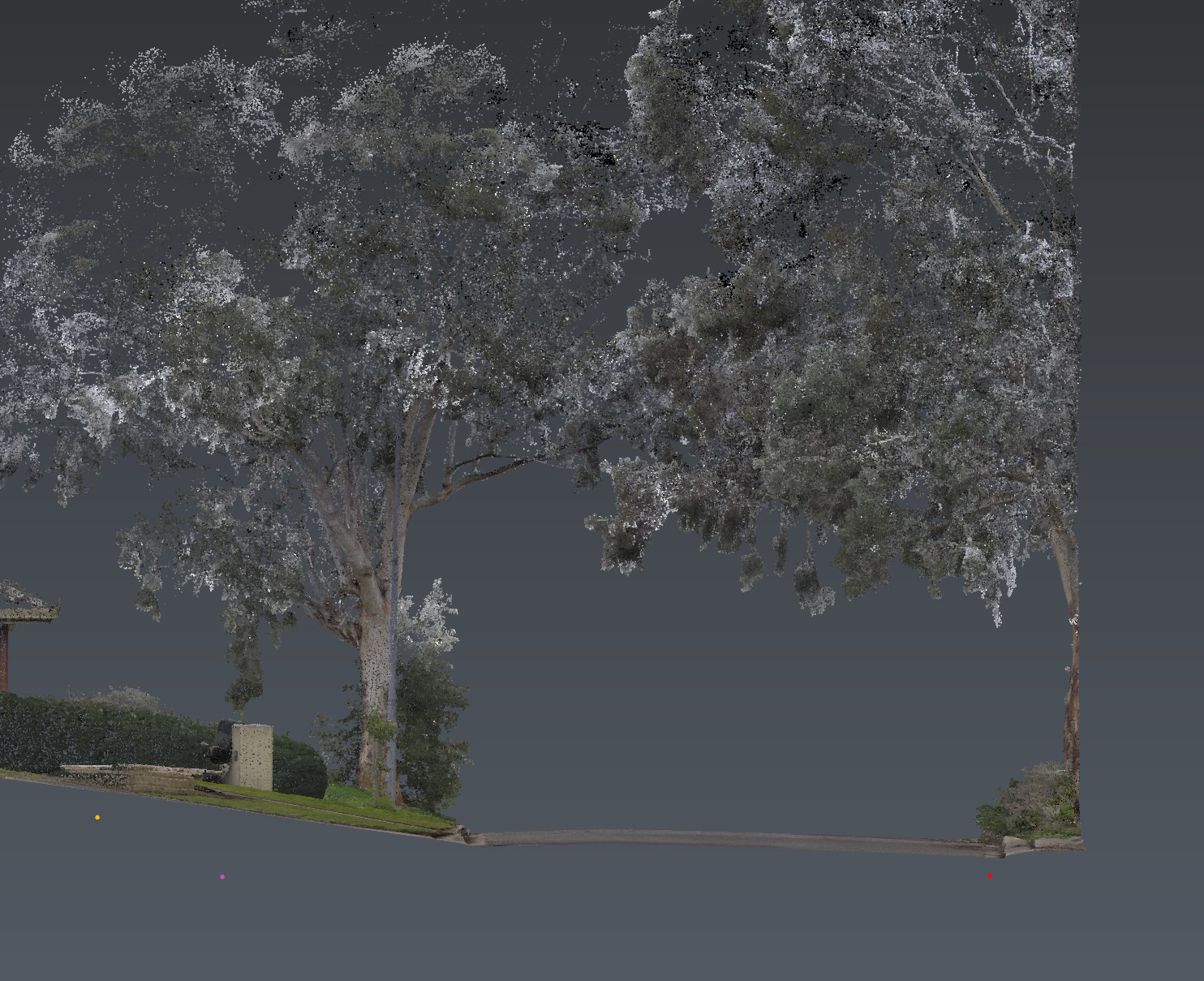
LiDAR reality capture among street trees in Adelaide for tree constraint mapping

Tree and root constraint mapping · Adelaide

The tree, the design
and the ground.

Reality capture · targeted GPR · utility locating · CAD / GIS / BIM

Tree and root constraint mapping in Adelaide: above-ground tree structure, candidate root corridors, buried services and design conflicts — in one controlled model — before construction begins.

This is not an arborist report. We support the project arborist. We do not determine viability or the TPZ.

Adelaide · South Australia · Australia-wide

AS 4970:2025-informed. Not certified.

Aus-OMI maps tree constraints for roads, trenches and development in Adelaide — LiDAR, multiarray GPR and utility locating, issued as spatial evidence for the project arborist.

The problem

Conflicts get locked in after the alignment is frozen.

Roads, trenches, footings and services meet protected trees when it is expensive to move anything. Under AS 4970:2025, encroachment is assessed against the Notional Root Zone, not the fence. The arborist owns the tree. The missing layer is a registered spatial model of the site, the design and the ground.

What we found
Tree geometry, design clash, candidate corridors, utilities — with evidence attached.
What we did not
A complete branch model. Every root. Live or dead status. Exact diameter from GPR.
What should happen next
Shift a trench. Hold a footing. Expose here. Proceed. Or stop.

The model

One site. Layers you can turn on.

Point cloud, crown, NRZ, SRZ, arborist TPZ, current design, utilities, GPR coverage, candidate corridors, verified roots. Spatially related, not three files that almost line up.

Demonstration model

Illustrative model. Project deliverables use site-specific survey, investigation and design data.

CARRIAGEWAYVERGEGPR COVERAGEWATER · COMMSTRENCHVERIFIEDT001T002T003N10 m

AS 4970:2025

NRZ, SRZ and TPZ are not the same line.

The 2025 edition split what many still call “the TPZ”. We draw the three as separate layers because the standard does. Aus-OMI does not certify against AS 4970. An arborist should review this language before it is used on a job.

NRZ — Notional Root Zone

  • Calculated root zone: Diameter at Standard Height (DSH) × 12
  • Minimum 2 m, maximum 15 m, measured from stem centre
  • The input to encroachment assessment — not the fence on site
  • Physical DSH remains tape. LiDAR does not replace it

SRZ — Structural Root Zone

  • Inner zone required for tree stability
  • Calculated when major encroachment is proposed
  • Uses diameter above the root buttress flare (DAB)
  • Any incursion into the SRZ is a major matter for the arborist

TPZ — Tree Protection Zone

  • The on-site protection area, determined by the project arborist from the NRZ
  • May be reshaped, with ground protection and compensatory area
  • Consent authority may specify it
  • Aus-OMI does not determine the TPZ
Minor encroachment
10% or less of the NRZ area, with no SRZ intrusion.
Moderate encroachment
More than 10%, up to 20% of the NRZ area.
Major encroachment
More than 20% of the NRZ area, or any encroachment inside the SRZ.

Encroachment is assessed against the NRZ, not the fence. Classification sits with the project arborist. Amendment 1:2025 (AS 4970:2025 Amd 1:2025) applies to Clause 1.4.15, Figure 1 and Figure 3(d). The published amendment text is not reproduced here. Zone geometry in the demonstration model is illustrative — not a substitute for the current figures, or for the arborist’s determination on a real site.

Above ground

What LiDAR can promise.

Observed

  • Tree centre and local ground elevation
  • Trunk geometry and lean
  • Tree height and cardinal crown spread
  • Lowest visible branch and visible major limbs
  • Clearances to buildings, plant, roads and overheads

Not promised

  • A complete internal branch model
  • Physical DSH — tape remains the calculation basis
  • Manufacturer accuracy as a project statement
  • Occluded geometry treated as measured

Every extracted feature is classified observed, derived, inferred or occluded. Leaves, overlap and wind hide structure. The defensible output is a crown envelope plus visible major-limb geometry.

Below ground

Targeted GPR. Only where it changes the decision.

Candidate coarse-root corridors and subsurface anomalies within a defined conflict area. Dual-polarisation multiarray coverage. Confidence rated. High is earned.

We map
Corridors by depth band and confidence. Coverage you can see. Gaps named.
We do not claim
Every root. Exact diameter. Live or dead. Proof that none are present.
No-response
Is not proof of absence. Direct exposure stays where the consequence requires it.

Adelaide clay, fill, moisture and reinforcement are named in the limitations. If the ground will not support the method, we say so and convert to LiDAR, conflict modelling and coordinated AirSpade or hydrovac. That is not a failed investigation.

Responsibility

Who does what.

Aus-OMI

  • Spatial control and georeferencing
  • RS10 capture and tree / terrain modelling
  • Stream DP acquisition and interpretation
  • EMI locating, design overlay, CAD / GIS / BIM
  • Coverage, uncertainty and limitation reporting

Project arborist

  • Species, health, structure, ULE, retention
  • Physical DSH and DAB
  • Root significance and condition
  • Viability, risk and the actual TPZ
  • AIA, TPP, TPS and certification

Handover

What you receive.

  1. 01

    PDF evidence report

  2. 02

    DWG / DXF and GIS package

  3. 03

    Point cloud (LAS / LAZ / E57)

  4. 04

    Interactive 3D they can actually open

  5. 05

    Candidate and verified root schedule

  6. 06

    Coverage and limitations plan

Cyclone 3DR is production software. Most clients do not have it. Default interactive delivery is a 3D PDF, Navisworks or a web viewer.

Applications

Where tree constraint mapping is used.

Roads and streetscapes

Trees, levels, drainage and constructability in one model.

Utility corridors

Trenching and crossings through protected trees.

Development

Footprints, basements, footings and access before DA freeze.

Campuses and estates

Recurring works against a controlled tree layer.

Questions

Before you brief us.

Do you map tree and root constraints in Adelaide?
Yes. Aus-OMI is based in Adelaide and maps above-ground tree geometry, candidate coarse-root corridors and buried services into one georeferenced model for tree-sensitive roads, utilities and development. We work Australia-wide.
Is this an arborist report under AS 4970:2025?
No. We do not determine viability or the Tree Protection Zone. NRZ is a calculation. TPZ is determined by the project arborist. We supply the spatial evidence they work from — AS 4970:2025-informed, including Amendment 1:2025, not certified.
What is the difference between NRZ, SRZ and TPZ?
Under AS 4970:2025 the Notional Root Zone (NRZ) is the calculated root zone from Diameter at Standard Height. The Structural Root Zone (SRZ) is the inner zone required for stability. The Tree Protection Zone (TPZ) is the on-site protection area the project arborist determines from the NRZ. They are not the same line.
How is encroachment assessed under AS 4970:2025?
Encroachment is assessed against the NRZ area, not the fence. Minor is 10% or less of the NRZ. Moderate is more than 10% up to 20%. Major is more than 20% of the NRZ, or any encroachment into the SRZ. The project arborist classifies it. We supply the geometry they measure from.
Can GPR map tree roots in Adelaide?
We map candidate coarse-root corridors with dual-polarisation multiarray GPR in a defined conflict area, with coverage and confidence stated. Adelaide clay, fill, moisture and reinforcement are named in the limitations. No-response is not proof of absence.
Does GPR find every root?
No. We map candidate coarse-root corridors within a defined conflict area, with coverage and confidence stated. Diameter, live or dead status, and significance stay with the arborist and with exposure where the consequence requires it.

Also in Adelaide

The same investigation, other jobs.

Tree constraint mapping is an application of the five methods — not a sixth method. GPR, locating and reality capture stay on their own pages.

Next

Send the drawings.
We reduce uncertainty before works begin.

Road, trench, footing or a DA overlay through protected trees. Brief us from Adelaide. We work Australia-wide.