
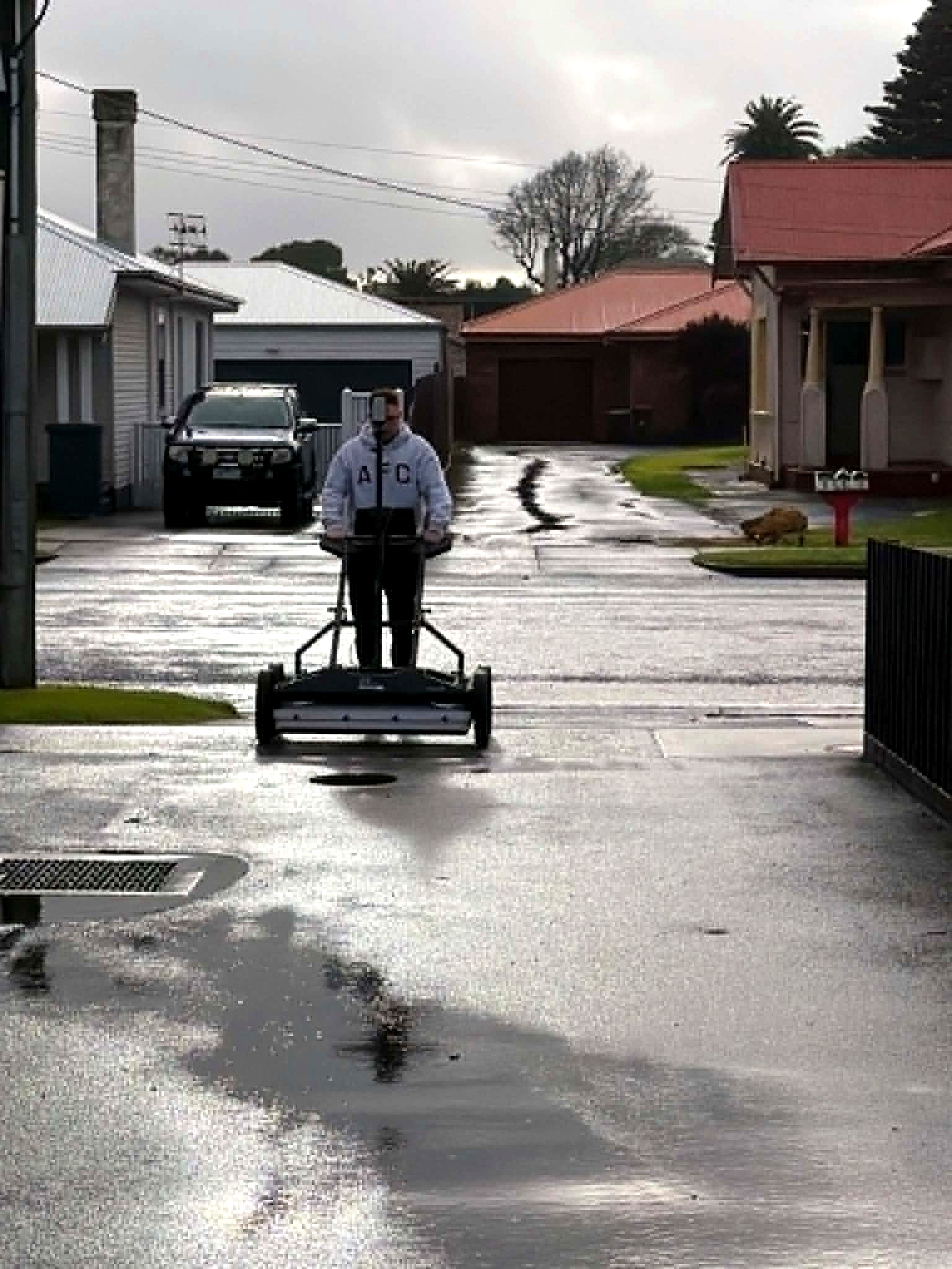
Multiarray GPR investigating underground utilities on a civil works street before excavation

Applications · Civil construction

Utility locating

Underground service locating for civil construction — pipes, cables and undocumented utilities investigated before excavation.

Aus-OMI locates underground utilities for civil works, road upgrades, utility renewals, precincts and brownfield sites.

Adelaide · South Australia · Australia-wide

Underground services. Civil works. Before excavation.

Knowing approximately where a service runs is useful.

Knowing what was detected, how it was detected, where it sits in three dimensions, what evidence supports the interpretation, and what uncertainty remains is considerably more useful.

Aus-OMI combines multiarray ground penetrating radar, electromagnetic locating, spatial control and reality capture to investigate underground utilities as a coordinated dataset. A digital record of the subsurface environment. Based in Adelaide. Working Australia-wide.

Underground services

Utility locating is the investigation of underground services that can affect a civil project.

Communications, electrical, water, sewer, gas, drainage, irrigation and abandoned infrastructure that never appeared on the drawing.

Existing plans and records are an important starting point. They are not an image of what is actually underground.

Private services, undocumented alterations, abandoned infrastructure, non-conductive pipework, incorrect alignments and unknown features can all exist outside the available records. Aus-OMI investigates the ground itself.

Conductive assets
Traced using electromagnetic locating.
Surrounding subsurface
Densely captured using multiarray GPR. Radar evidence processed and interpreted in three dimensions.
The objective
Not simply to locate known services. Identify and communicate the underground environment that could affect the project.
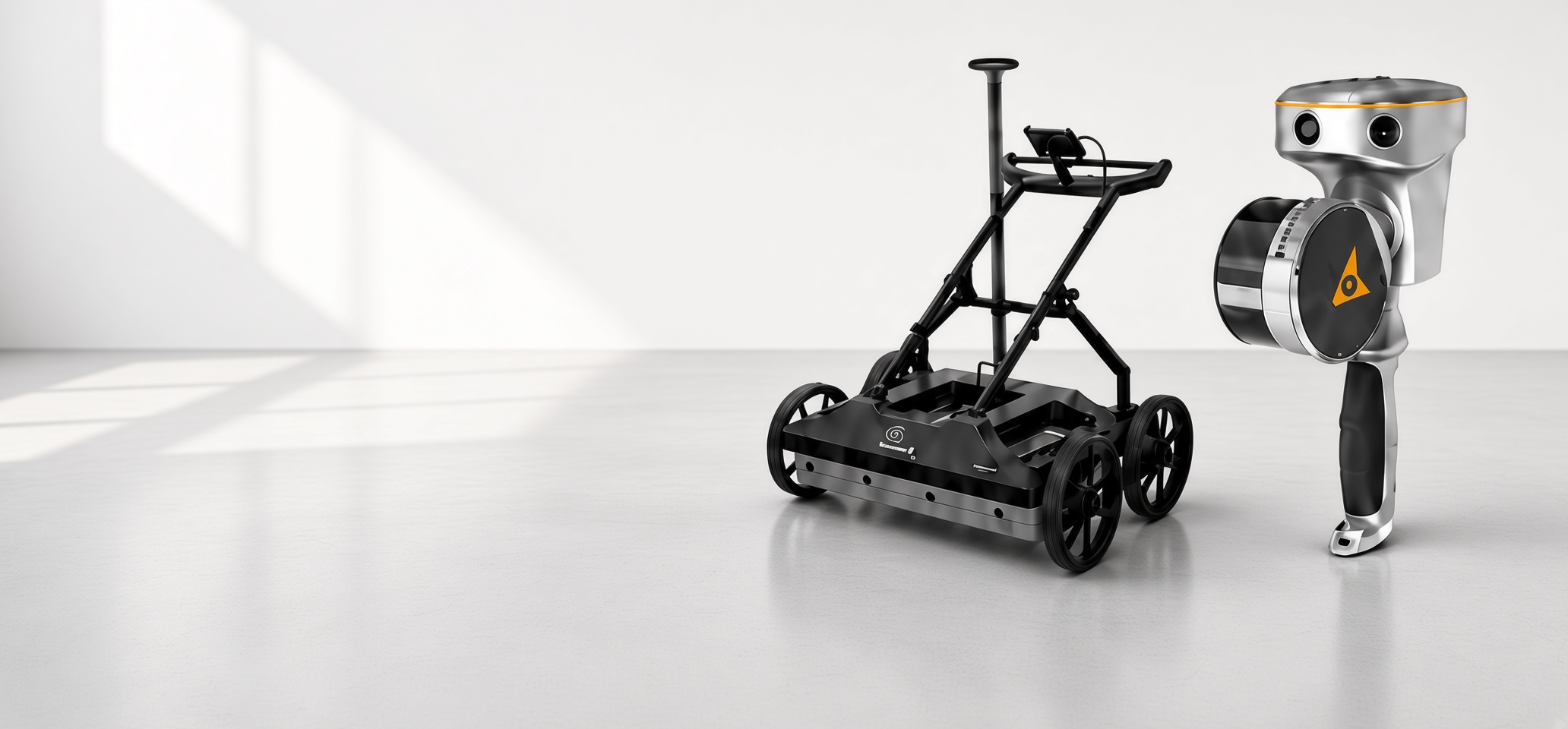
IDS GeoRadar Stream DP multiarray GPR — thirty channels, two polarisations

IDS GeoRadar Stream DP

Thirty channels. Two polarisations. One dense subsurface dataset.

Aus-OMI deploys the IDS GeoRadar Stream DP as its primary GPR platform for utility locating and underground utility mapping.

Unlike conventional single-channel GPR, Stream DP uses a dense multiarray configuration to capture the ground continuously across the survey area.

19
VV channels
11
HH channels
30
channels acquired together

Dual-polarisation acquisition means buried features can be interrogated from different orientations rather than relying on a single radar profile crossing a target at the right angle.

IDS GeoRadar’s Equalized scrambled Technology — EsT — is designed to retain both penetration and resolution within the same acquisition. For utility locating, that means considerably more information is captured about the ground in every pass.

The result is not a collection of isolated radar lines. It is a georeferenced subsurface volume.

IQMaps

From radargram to underground map.

IQMaps turns dense acquisition into interpretable evidence. Capturing GPR data is only the beginning. Aus-OMI processes Stream DP datasets within IDS GeoRadar IQMaps.

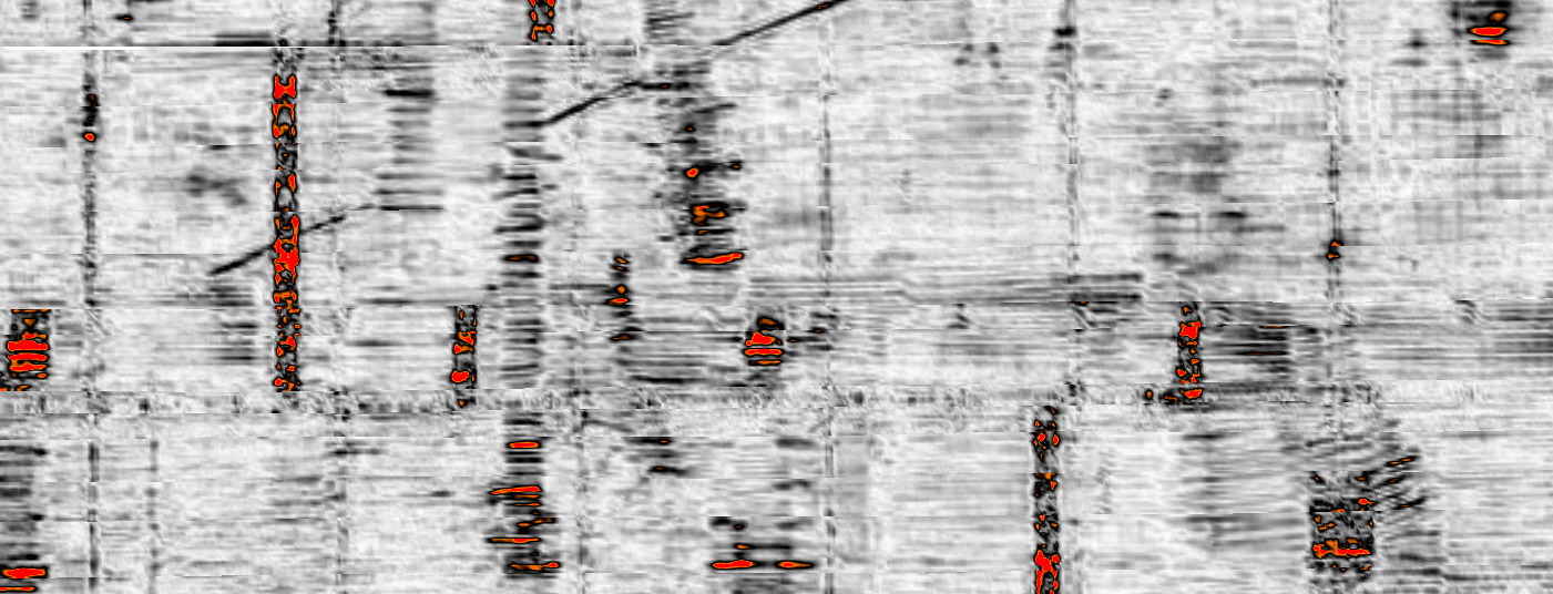
The dataset can be investigated through individual radar profiles, depth information, plan views, 3D visualisation and tomographic slices through the subsurface.

Instead of looking only for a hyperbola on an individual radargram, the interpreter can examine whether a response continues spatially through the captured volume.

  • Utilities can be followed through the survey.
  • Crossings become visible.
  • Parallel services can be separated.
  • Changes in depth can be investigated.
  • Unknown linear features can be correlated against the surrounding network.

Every interpreted utility is built from evidence contained within the dataset.

AiMaps 3.0

AI-assisted subsurface interpretation.

AiMaps 3.0 adds another analytical layer. Large multiarray GPR surveys can contain an enormous amount of radar information.

AiMaps 3.0 provides an AI-assisted processing environment integrated with IQMaps and developed specifically for IDS GeoRadar utility-mapping systems including Stream DP.

Deep-learning processing can enhance tomography and assist the interpreter in identifying underground infrastructure within complex radar datasets. Pipe Tracer functionality can support automated tracing and digitisation of continuous underground utilities.

For Aus-OMI, AI is not used to replace interpretation. It is another analytical layer.

  • Raw radar evidence remains available.
  • IQMaps remains available.
  • Electromagnetic locating remains available.
  • Existing records remain available.
  • Site context remains available.
  • The interpretation is checked against all of them.
GPR tomography time-slice used to interpret underground utilities as a volume

Ground penetrating radar and electromagnetic locating

Different physics. Different evidence.

There is no single instrument that finds everything underground.

Electromagnetic locating

Extremely effective for tracing conductive utilities — live cables and metallic pipes — when an appropriate signal can be applied or detected. It cannot directly locate every plastic, concrete, abandoned or otherwise non-conductive feature.
Ground penetrating radar

Works differently. It images changes within the subsurface and can therefore provide evidence of infrastructure whether the target conducts electricity or not.

Aus-OMI uses both methods because disagreement between them can be important.

Both agree
A conductive trace with corresponding radar evidence is stronger than either observation alone.
Radar only
A radar feature where no conductive response exists may indicate non-conductive or abandoned infrastructure.
Neither method
A record showing a utility where neither method provides convincing evidence is also meaningful.

The objective is evidence correlation, not dependence on one instrument.

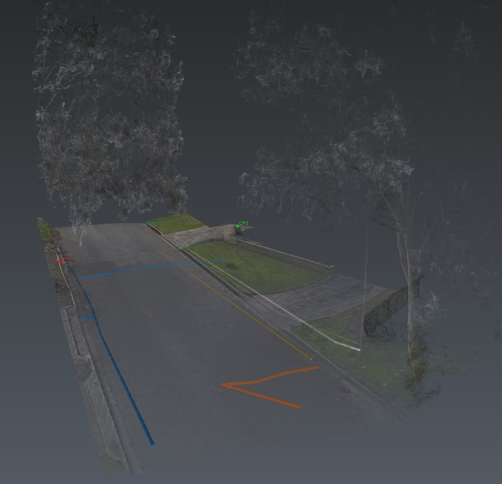
Interpreted underground utilities in a coordinated 3D site environment

A spatial environment

Everything belongs somewhere.

Every useful underground interpretation ultimately needs to relate back to the real site.

Aus-OMI establishes spatial control and georeferences the investigation so interpreted utilities can be delivered in the same coordinate environment used by surveyors, engineers and civil designers.

  • Reality capture provides the surface context.
  • GPR provides the subsurface evidence.
  • Electromagnetic locating provides another independent detection method.
  • Existing plans and records provide historical context.
  • The interpreted utility model brings those sources together.

The result can be reviewed against kerbs, pits, structures, pavements, buildings and other visible site features instead of floating independently on a sketch.

Evidence

We don’t hide the radar behind the drawing.

The evidence matters. A utility line on a CAD drawing is an interpretation. Aus-OMI retains the evidence that produced it.

Where appropriate, significant interpreted features can be related back to radar responses, tomography, depth information, electromagnetic evidence and site observations.

That matters when a civil project team asks:

  • Why do you think the service runs there?
  • How confident are you?
  • What happened through this congested section?
  • Why does your interpretation disagree with the existing plan?
  • Where did detection quality deteriorate?
  • What remains uncertain?

Those questions should have answers.

Handover

What the civil project receives.

A utility locating investigation, issued as a digital record. Depending on scope, an Aus-OMI utility locating package can include:

  1. 01

    Digital Site Intelligence Report

  2. 02

    interpreted underground utilities — pipes, cables and undocumented services

  3. 03

    AS 5488 quality information

  4. 04

    utility depth information

  5. 05

    investigation coverage and exclusions

  6. 06

    residual uncertainty and recommended verification

  7. 07

    interactive 3D site environment

  8. 08

    CAD / GIS outputs

  9. 09

    KML

  10. 10

    reality-capture point cloud

  11. 11

    GPR tomography and supporting imagery

  12. 12

    coordinate reference and survey metadata

The locate is the investigation. The handover is the record the next drawing and the next excavation decision can use.

Where it is used

Anywhere the consequence of discovering the underground environment during construction is greater than the cost of investigating it beforehand.

  • Civil construction.
  • Road upgrades and reconstruction.
  • Utility renewals and service relocation.
  • Industrial facilities.
  • Defence and secure sites.
  • Brownfield redevelopment.
  • Hospitals and campuses.
  • Precinct and subdivision works.
  • Design coordination.
  • Excavation planning.
  • Sites with incomplete or contradictory records.

Limits

Detection is not verification.

We say what the technology cannot prove. Ground penetrating radar is geophysical evidence. Electromagnetic locating is geophysical evidence. Neither is physical exposure.

Ground conditions, material properties, reinforcement, congestion, depth, access and acquisition geometry can all influence detection. Aus-OMI reports those limitations rather than burying them.

Where physical certainty is required, targeted exposure or potholing remains the appropriate next step. The purpose of the utility locating investigation is to make that next step substantially more informed.

The investigation

Capture the ground. Interrogate the data. Build the model.

Then make the decision.

Modern multiarray GPR can capture the subsurface as a dense dataset. IQMaps can interrogate that dataset as a volume. AiMaps can assist with processing and utility extraction. Electromagnetic locating can independently trace conductive infrastructure. Reality capture can document the environment around it. Spatial control can bring everything together.

Aus-OMI turns those technologies into one coordinated utility locating investigation.

What we found
The underground environment that could affect the project — with evidence attached.
What supports it
Radar, electromagnetic locating, records and site context, correlated.
How confident we are
Stated beside the interpretation. Not implied by a line on a drawing.
What remains uncertain
Written down. Residual unknowns stay on the record.

Next

Send the drawings.
We reduce uncertainty before works begin.

Corridor, precinct, brownfield or a street with no records. Brief us from Adelaide. We work Australia-wide.